Introducing ConcreteVision™ (See through concrete decks)

Developers, Construction Management Companies and Contractors — stop guessing where the pipe or electrical conduit is located.  With our new ConcreteVision™, you can see the exact as-built without calling out a concrete x-ray crew.

Take a look at this side-by-side comparison of a portion of a site — please contact us if you are interested.

Here is a live example from a recent construction project:


[Note: These maps are not surveys or certified by a licensed surveyor. With surveyor ground control points, these “pre” & “post” pour maps will overlay with other site maps perfectly. They are just pretty pictures until they are geo-referenced and certified.]

Happy New Year from the Sky Ladder Drones team!

Happy New Year from the Sky Ladder Drones team! First, thank you to all our customers in 2019!

And a special thank you to our pilots, visual observers and partners.  When I started adding the names of people who helped pilot or VO (visual observer) during in 2019, I was amazed to compile a list of 32 total people!!!  Thank you to these pilots/VOs — look at the sky of the panorama to see the names of everyone on the team who helped make this a great year!

It was a beautiful day in Los Angeles yesterday when I captured this 360 degree panorama at the top of the Palos Verdes Peninsula — with views of snow-capped mountains, downtown, Hollywood, Malibu, Catalina and Orange County.

We wish you a healthy and prosperous 2020!

Click here:  360 Panorama

(see our team’s names in the sky of the panorama)

San Pedro Radar Tower – Palos Verdes, California (Sky Ladder Drones – 12/31/2019)

A Great 2D Mapping Example – Capturing the Changing Landscape at Madrona Marsh

What a difference one month of rain makes!

As you probably know, we donate a weekly mapping capture to Madrona Marsh in Torrance, CA — and this has provided the Marsh staff and volunteers with an invaluable tool for the management of the Marsh. And today’s capture has shown a significant difference in water levels compared on only one month ago.

Take a look at a side-by-side maps on how much the Marsh has changed from December 2019 storms which dropped 4.87 inches of water:

https://www.skyladderdrones.com/projects/2d-mapping_madrona_marsh-2/

The Madrona Marsh is one of the last remaining vernal freshwater marshes in Los Angeles County — and 100% fed by rainfall.

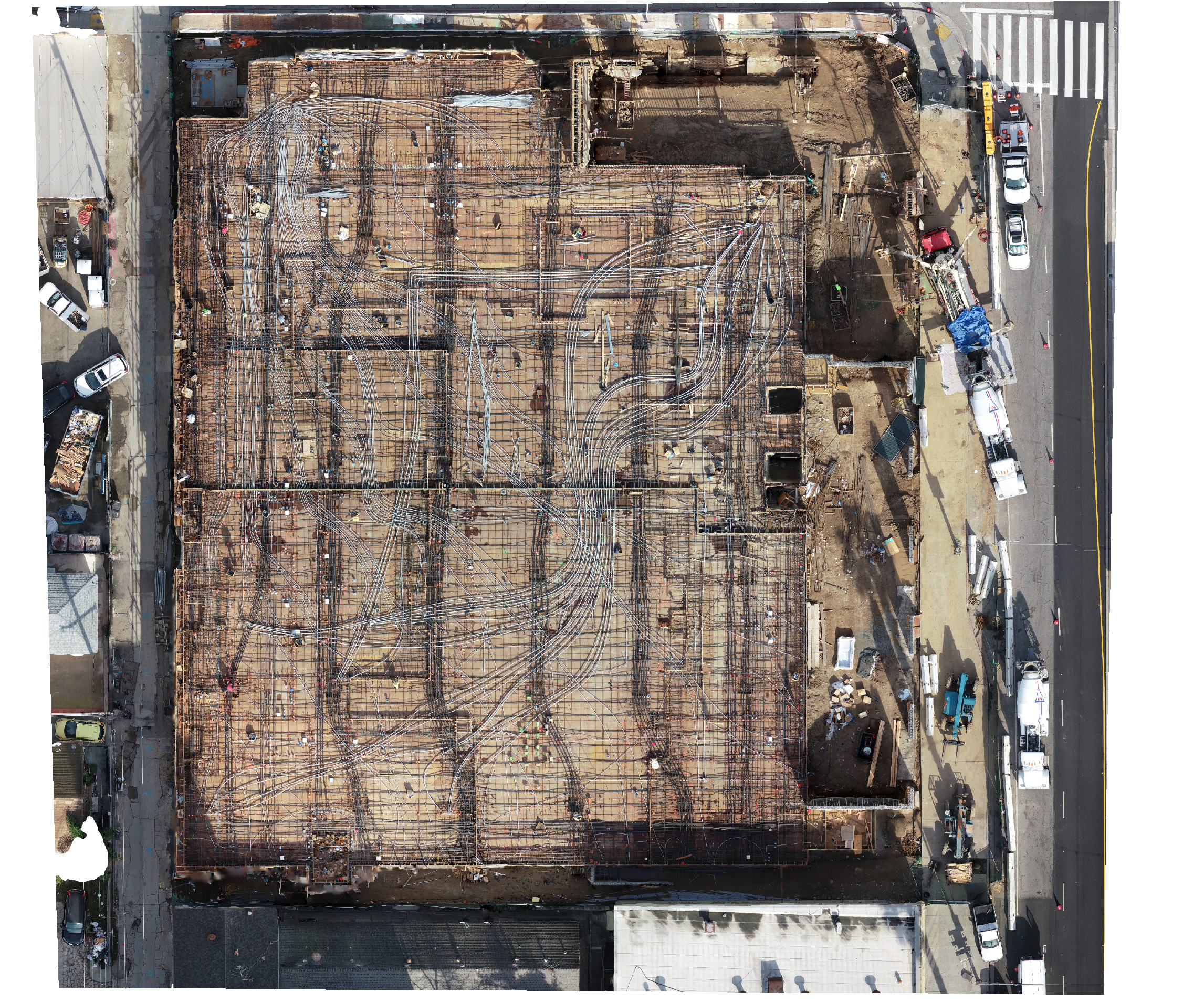
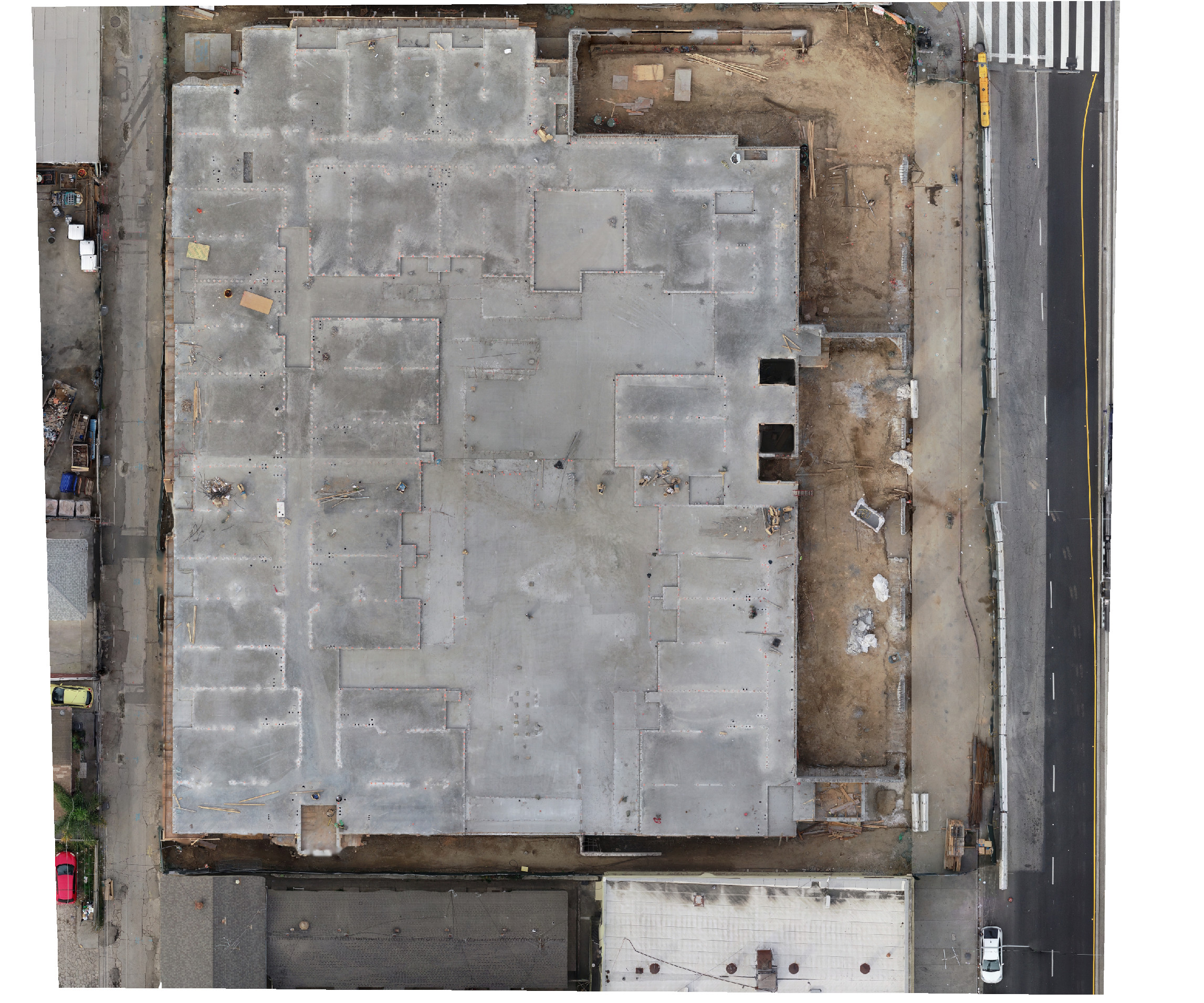
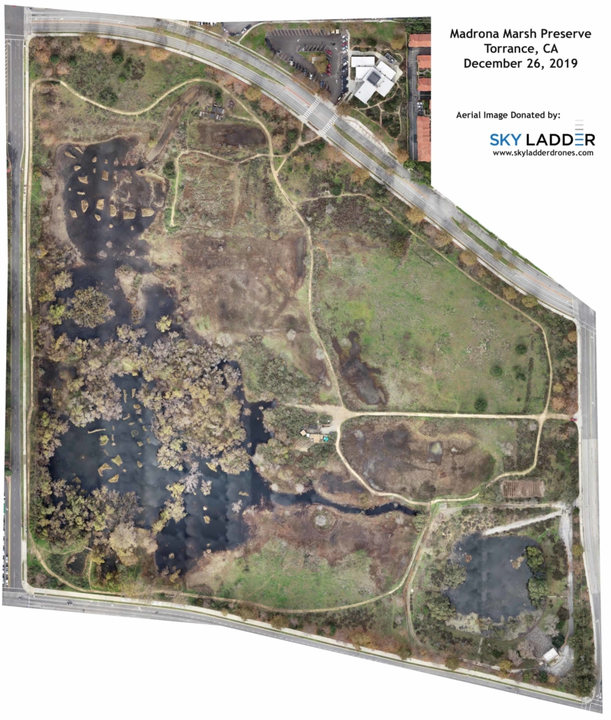
These maps were created by combining 399 drone photographs into an orthomosaic image. Think of it as a high definition Google Map (10x the resolution) that YOU determine when it is captured.

Do you have a remodel, construction project, parking lot or even a wildlife preserve you want to track over time? Sky Ladder Drones can help you create high definition maps — and you control when and where you share the maps. And, by combining the services of a licensed surveyor, these maps turn from pretty pictures to measurements and data. Give us a call or drop us an email.

Here’s a high resolution image of today’s mapping capture:

[Note: These maps are not surveys or certified by a licensed surveyor. They are just pretty pictures until they are geo-referenced and certified.]

Topping Off Ceremony at Historic Vision Theater in Leimert Park

Peter did a terrific job at the Vision Theater in the Leimert Park neighborhood of Los Angeles today.

He captured the final structural steel being set at the historic Vision Theater.

Weekly Drone Mapping of Madrona Marsh Captures First Rainstorm of 2019/2020 Season

This week was the first rain of the 2019/2020 winter season here in the Los Angeles area — and we spent a couple hours documenting how the 43 acre Madrona Marsh has “come to life.”

As a longtime volunteer at the Madrona Marsh and Preserve, we’ve been documenting the seasons at the Marsh for the last year. Our mapping has allowed the Marsh management team to track water levels, vegetation growth, and serving as an overall management tool.

Our mapping capture of 399 images on Saturday, November 30, 2019, shows how 1.08 inches of rain immediately changes the Marsh with both water and wildlife. See a “Before/After” map of this first season rain here:

https://www.skyladderdrones.com/projects/2d-mapping-nov-example-madrona-marsh

***A special thank you to Torrance Airport Air Traffic Control for working with us to approve weekly airspace authorizations in what is designated as a “No Fly Zone.” These flights have enabled us to provide this resource to the Torrance city-owned Madrona Marsh and Preserve.

Successful Flights in March Air Reserve Base “Zero Grid” to Capture New Construction Progress

I had a great morning with Desiree and Mariel capturing a construction progress job. Besides being a beautiful day, it was really cool flying near March ARB with “real-time deconfliction” coordination with their air traffic control. But, when you get a call from ATC to advise you that there will be UAV activity we need to avoid — you don’t expect a huge Reaper UAV doing touch-and-goes nearby. (at least I think it is a Reaper from the attached picture Desi took.) #zerogrid #ATC-Called-US!

1 mile from March ARB – with “real-time deconfliction”

Our team Onsite (and yes, that is Desi in a pink safety vest!)

We finished just as the Reaper UAV began flying training missions nearby.

Mapping Mission Adjacent to Torrance Airport

We recently got a call from a property owner who wanted a precision map of their property. After learning about their needs, the first question we asked was — what is the address of your property so we can confirm it is someplace we can safely fly. When the owner shared that the site was just across the street from Torrance Airport (Class D airspace) we immediately shared that his property’s location might be an issue… but that we’d try to get authorization.

We regularly fly in what is considered “zero grid” or “do not fly” airspace, but this was the closest to Torrance Airport we would had ever flown. So, after reviewing flight patterns and the heights of surrounding buildings, we submitted a request to the airport for our 1 hour flight. We included mitigation to fly lower that usual — but which would avoid any possible conflicts with aircraft. We also shared that we would monitor the airport’s traffic on a special airport traffic frequency radio to ensure a safe mission.

We received permission to fly a few days after submitting our request and we took this “selfie” of intern Mariel and pilot Steven just to document the historic (and safe) event.


Mariel and Steven all setup in a parking lot adjacent to Torrance Airport.

Sky Ladder Drones Supports the FAA’s National Drone Safety Week at Redondo Union High School

Partners WH4, Flying Lion and Sky Ladder Drones supported the FAA’s National Drone Safety Week with a demonstration/presentation during lunch at Redondo Union High School. #DroneWeek #FAANationalDroneSafetyWeek Sky Ladder Drones


Some stickers we handed out.


Barry Brennan of Flying Lion being interviewed by RUHS student TV.

New Randy’s Donuts in Downey

We got to capture history this week with the 2nd ever Randy’s Donuts sign being installed. Yes, it’s a deviation from our construction site mapping work — but I would definitely call it historic documentation! Randy’s Donuts

Congratulations to Randy’s Donuts and San Pedro Electric Sign Company (SPESCO) for the flawless sign fabrication and installation.

Randy’s Donuts new Downey, CA location — Grand opening on October 23, 2019 at 5am!!!

Verifly Case Study Featuring Sky Ladder Drones Published Today

I was interviewed by insurance carrier Verifly a few weeks ago who supplies “on demand” insurance to the drone industry (and now just added General Liability insurance ‘on demand.’)  They did a good job capturing how we use their products.

Their insurance offering allows thousands of “startup” pilots to fly responsibility (with drone liability insurance) — which is exactly what it did for us here at Sky Ladder Drones.  The Verifly offering now provides us the ability to add insurance for additional drones “on demand” when we have large jobs beyond our standard annual liability policy. And, their new offering of ‘on demand’ General Liability insurance is really reasonable when our customers require it.